


Wash Park
The short answer
Wash Park is what people call two official Denver neighborhoods, Washington Park and Washington Park West, along with the 165-acre city park at the line between them. It's in south-central Denver, with I-25 along the southern edge. Homes are mostly older brick houses, including Tudors and Denver squares, plus large remodels and some older houses split into multiple units. RTD light rail stops just outside the boundary at Louisiana–Pearl Station in Platt Park, and I-25 connects the area to the rest of the metro.
Watch: Jimmy's video on this area
What is living in Wash Park like?
Wash Park is one of my absolute favorites. It's really like the Denver lifestyle showcase. On a sunny day, especially a weekend, people are everywhere: walking, running, biking, playing volleyball. You can rent a boat, and there's tennis, basketball and a walking track. Nearby streets have walkable pockets of shops and restaurants, and the homes run to Tudors, Denver squares and large remodels.
Start with one distinction. Washington Park is a city park. Washington Park and Washington Park West are neighborhoods, two of the statistical neighborhoods Denver uses for its data and records. "Wash Park" is the everyday name for all of it. This guide covers both neighborhoods and the park. If you're still choosing a part of the metro, start with the Denver relocation guide.
What draws people here
- The park. It's about a mile long and a quarter-mile wide, with two lakes and what History Colorado calls the largest meadow in Denver's park system.
- The flower beds. The park's state register entry credits it with the largest formal summer flower beds in the Denver park and parkway system.
- Shops close to houses. South Gaylord Street and Alameda Avenue are commercial areas in the neighborhood, and smaller corner-store areas sit at stops on the former streetcar lines.
- Older brick houses. Most of the houses here were built of brick between 1900 and 1940.
- A city recreation center. Washington Park Recreation Center, at 701 S. Franklin St., is a regional-level center with a pool.
What gives people pause
- Home age. A house built between 1900 and 1940 can come with old sewer lines, old water lines and an old foundation. Plan your inspections around that.
- Scrapes and pop-tops. Some older homes here get a second story added or are torn down and rebuilt, so a block can change after you buy.
- Parking. If you're counting on street parking, read the posted signs on any block you're considering and ask whether permit rules apply.
- Busy park days. Sunny weekends draw a crowd, and big events add to it.
- Rail isn't on your corner. Louisiana–Pearl Station is in Platt Park, about 1,500 feet west of the park, so plan on a walk, a bike ride or a bus to reach it.
- Flood maps. Cherry Creek forms the northern line of Washington Park, so check FEMA's map for any address close to the creek.
Where is Wash Park, and how do you get around?
Wash Park sits in south-central Denver. I-25 runs along the southern edge, Broadway marks the west side and University Boulevard marks the east side. As of fall 2026, RTD's Downtown Rail Reconstruction Project has changed some light rail service, so confirm your trip with RTD before you count on it.
- Into downtown: Light rail from Louisiana–Pearl Station normally runs to Union Station, and RTD's Route 0 bus runs on Broadway, the western edge of Washington Park West.
- Into the Tech Center: I-25 runs along the southern edge, and light rail parallels it south from Louisiana–Pearl to the Belleview and Orchard stations.
- Transit: Louisiana–Pearl Station is the closest rail stop to the park, and the I-25 & Broadway station serves the west side. RTD bus routes 11 and 12 connect at Louisiana–Pearl, and Route 11 runs on Mississippi Avenue. Which rail lines stop there is changing during the rail project, expected to finish by the end of 2027, so check RTD's current map.
- The airport: RTD commuter rail runs directly between Union Station and Denver Airport Station. By car, take I-25 north to I-70, then I-70 east to Peña Boulevard.
- The mountains: I-70 connects Denver and Grand Junction through the Rocky Mountains. From Wash Park, take I-25 north to the Mousetrap interchange and go west.
Where does Wash Park start and stop?
The official lines come from Denver's statistical neighborhoods. Denver has 78 official neighborhoods, drawn from 1970s census tracts, and the city uses them for data, records and rezoning presentations. Denver has no formal process for designating a neighborhood, so everyday names like "Wash Park" don't change the map, which the city's Community Planning and Development department maintains.
The park
Washington Park runs from Virginia Avenue on the north to Louisiana Avenue on the south, and from Downing Street on the west to Franklin Street on the east.
Washington Park
The city defines this neighborhood's borders as Downing Street, Cherry Creek, I-25 and University Boulevard. You'll also see the north edge drawn at Bayaud Avenue and the Denver Country Club.
Washington Park West
This neighborhood runs along the park's long western edge. Its borders are Alameda Avenue on the north, Downing Street on the east, Mississippi Avenue and I-25 on the south, and Broadway on the west. City statistics have tracked it separately from Washington Park since 1972.
Nearby areas often confused with it
South Pearl Street is the classic mix-up. It's in neighboring Platt Park, though it's often placed in Washington Park. Louisiana–Pearl Station is in Platt Park too. On the east side, University Boulevard separates Washington Park from Belcaro and Cory-Merrill. If the name matters to you, go by Denver's map, not the name on a sign.
What does it cost to own a home in Wash Park?
Prices and tax amounts change, so this guide points you to where to check them. These are the costs that apply here.
- Property tax: Denver's property search shows assessment and tax data by address, parcel ID or schedule number. The city notes that some charges, such as maintenance district fees, service lien fees and business improvement fees, may not always appear, so ask about them for the specific property.
- Sidewalk fee: Denver property owners have paid this fee since 2025. As of its 2025 rollout, it appears on the municipal stormwater bill in two payments a year, and properties with a long street frontage pay an added amount. Owners still have to keep sidewalks clear of snow, ice and debris.
- Landmark rules: Denver's design guidelines apply to individually designated landmarks and historic districts. As of fall 2026, the list of Denver landmarks shows no historic district named for Washington Park or South Gaylord, but it does list Smith's Ditch (City Ditch) as a historic district, and the ditch's open section flows through the park. Individual landmarks exist here too, including Myrtle Hill School at 1125 S. Race St. and the Neahr House at 1017 S. Race St. Check the specific address before you plan exterior work.
- Older-home systems: Denver Water's address lookup shows a property's risk of lead in drinking water, and its Lead Reduction Program replaces lead service lines with copper. Colorado's health department says radon can enter homes from the ground beneath them, so test for it. Get a sewer scope on any older house.
- HOA or condo dues: If a home has an association, find out what the dues cover and who pays the stormwater bill. When an HOA handles that bill, the HOA pays the sidewalk fee.
- Parking: If you're counting on street parking, find out whether the block has permit rules and what a permit costs.
- Flood insurance: FEMA's Flood Map Service Center lets you search the official flood map by address. Maps change over time, so run the search yourself and ask your insurance agent what it means for that home.
What kinds of homes are in Wash Park?
Expect brick. Most of the houses were built of brick between 1900 and 1940, and some brick houses date to the late 1800s. You'll see Tudors, Denver squares and large remodels. Pop-tops and scrapes mean newer work can sit beside much older houses. In Washington Park West, many early-20th-century houses have been converted into multiple units. Two houses show how far back the housing goes: the Neahr House, a Denver landmark, dates to 1894, and the Causey-Sterne House at 1190 S. Franklin St. dates to 1913.
How do schools work in Wash Park?
Both neighborhoods are in Denver Public Schools. DPS uses single-school boundaries in some areas and enrollment zones in others. In a zone, living there guarantees a spot at one of several schools, not one specific school. What applies depends on the address, so enter each home you're considering into DPS's School Finder. The SchoolChoice hotline can answer questions, and DPS posts enrollment zone guides for elementary, middle and high school.
What is there to do in Wash Park?
Parks, trails and open space
Washington Park covers 165 acres and is one of the largest of the fifteen parks in the Denver Park and Parkway System. Reinhard Schuetze laid it out, and by 1904 it had reached its present size. George Kessler added roads, paths and plantings in 1908, the Olmsted Brothers firm added features in the 1910s, and S.R. DeBoer later managed the park as Denver's chief landscape architect.
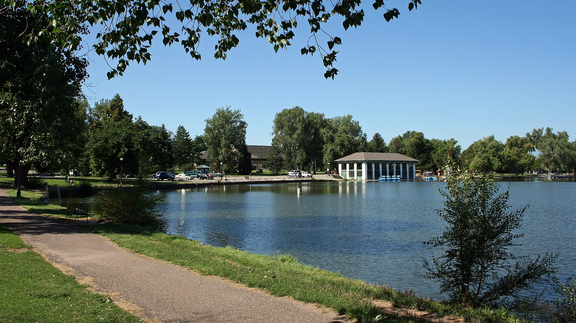
The water came first. Smith Lake was a natural depression until May 1867, when Smith's Ditch was completed. That ditch is now called City Ditch, and Denver Water says its primary job today is to irrigate and fill the lakes in Washington and City parks. Its open section still flows through the park. The ditch went on the National Register of Historic Places in 1976 and the park followed in 1986. Inside the park, the Boathouse, the Bath House and the Eugene Field House are individually designated Denver landmarks.
The park's history includes segregation. Smith Lake's north shore held Denver's first bathing beach, opened in 1911. The Denver Public Library's history says only the city's white population used it, citizens of Japanese descent were officially barred in 1913, and segregation affecting other minorities was in place unofficially. In 1932, 150 African Americans arrived intending to swim, and police arrested seventeen people. The beach closed in 1957.
For getting around the park, a dirt path of about 2.6 miles circles the outside, and a network of asphalt and gravel paths runs through it. The Loop Road is the paved inner loop, about 2.2 to 2.3 miles depending on the source. Boat rentals on Smith Lake are seasonal, so check the current schedule.
Events
The Mile High United Way Turkey Trot is held in Washington Park on Thanksgiving Day, starting at South High School on East Louisiana Avenue. The city also rents the Boathouse for private events in the warmer months.
Food and shops
South Gaylord Street is a commercial strip inside Washington Park, about six blocks east of the park. It's one of the city's old streetcar commercial districts, and the building at 1076–1078 S. Gaylord St. went up in 1913 with the Washington Park Bakery on the first floor. Alameda Avenue is another commercial area in the neighborhood.
Just outside the boundary, South Pearl Street is a shopping and dining corridor one block west of Louisiana–Pearl Station, in Platt Park.
Three places to start
- Washington Park Boathouse — Completed in 1913 and designed by Jules Jacques Benois Benedict. It stands on Smith Lake at 701 S. Franklin St., and the park is listed on the National Register.
- Perennial Garden — Dates to the late 1910s and has 54 flower beds. The Martha Washington Garden, a replica of her garden at Mount Vernon, followed in 1926.
- South Gaylord Street — An old streetcar commercial district. The 1913 building at 1076–1078 S. Gaylord St. is one to look for.
Who are the big employers in and near Wash Park?
The job centers closest to Wash Park sit outside its lines. Washington Park West is heavily residential, and the commercial areas in Washington Park are small pockets. Cherry Creek, across the creek to the northeast, has the Cherry Creek Shopping Center and the 16-block Cherry Creek North district. Downtown is to the north by I-25 or light rail. University of Denver Station is the next stop south of Louisiana–Pearl, and the line continues along I-25 to Belleview, Orchard and Arapahoe at Village Center stations. Employer rosters change, so treat these as the places to look rather than a ranked list.
How does Wash Park compare with nearby areas?
- Wash Park vs. Platt Park — Platt Park has the South Pearl corridor and Louisiana–Pearl Station. Wash Park has the park and South Gaylord Street. I'm in Wash Park and Platt Park all the time, and people who live in either one use the other because they're so close.
- Wash Park vs. Cherry Creek — Cherry Creek runs from the creek north to East Sixth Avenue, between University and Colorado boulevards, and it's anchored by a shopping center and a 16-block retail district. Wash Park is anchored by a city park.
- Wash Park vs. Baker — Broadway is the line. Washington Park West stops there, and Baker, with its National Register historic district, lies to the west.
- Wash Park vs. Belcaro and Cory-Merrill — University Boulevard is the eastern edge of Washington Park, and these neighborhoods sit on the other side of it.
Buying in Wash Park: what to do first
- Get pre-approved before you tour. Older brick houses and large remodels are different purchases, and knowing your numbers tells you which ones to look at.
- Confirm the neighborhood. Check the address against Denver's map, since Washington Park, Washington Park West and Platt Park are often blurred together.
- Pull the records. Use Denver's property search for assessment and tax data, and ask about any fees that may not show up there.
- Inspect for the home's age. Get a general inspection, a sewer scope and a radon test, and run the address through Denver Water's lead lookup.
- Check the address. Look up landmark status, FEMA's flood map, the block's parking signs and DPS's School Finder.
- Veterans: If you're using a VA loan, plan for the appraisal on a house this age. VA must ensure a financed home is suitable for dwelling purposes, and its minimum property requirements can bring up defects or maintenance issues. If you'd like a read on current pricing for the blocks you're considering, reach out and I'll walk you through it.
In pictures
Watch the videos
Help shape what Jimmy films next
Which town should Jimmy cover next, and what do you still want to know? Tell us, and we'll email you when the guide and video are out.
Thank you — this genuinely helps. We'll let you know when it's ready.
Frequently asked questions
What's the difference between Washington Park and Wash Park?
Washington Park is a 165-acre city park and also the name of a Denver statistical neighborhood. Washington Park West is a separate statistical neighborhood along the park's western edge. "Wash Park" is the everyday name for the whole area.
Where does Wash Park start and stop?
The city defines the Washington Park neighborhood by Downing Street, Cherry Creek, I-25 and University Boulevard. Washington Park West runs from Alameda Avenue south to Mississippi Avenue and I-25, between Broadway and Downing Street.
Is South Pearl Street in Wash Park?
No. South Pearl Street is in neighboring Platt Park, though it's frequently misidentified as part of Washington Park.
Is there light rail in Wash Park?
Louisiana–Pearl Station is in neighboring Platt Park, about 1,500 feet west of the park along East Louisiana Avenue. Service is changing during RTD's rail project as of fall 2026, so confirm the lines with RTD.
What school district is Wash Park in?
Wash Park is in Denver Public Schools. DPS uses boundaries in some areas and enrollment zones in others, so enter the specific address in its School Finder.
Is Wash Park a historic district?
The park and City Ditch are on the National Register of Historic Places, and there are individual Denver landmarks in the area. As of fall 2026, the list of Denver landmarks shows no historic district named for Washington Park, though it lists Smith's Ditch (City Ditch) as one, and the ditch's open section flows through the park. That list doesn't show boundaries, so check the specific address.
What should I check before buying an older home in Wash Park?
Get a general inspection, a sewer scope and a radon test, and run the address through Denver Water's lead lookup. Then check Denver's property search, landmark status and FEMA's flood map.
Take this guide with you
Get the printable PDF version to read offline, share with your family or mark up on your scouting trip. Enter your name and email and it's yours.
Thanks! Your guide is ready.
Download the PDFNo spam. Jimmy may follow up personally to see if you have questions about the move.
Sources
Guide reviewed November 3, 2026, and reviewed again twice a year.
- Wikipedia: Washington Park, Denver (park size and edges, neighborhood borders, Washington Park West tracked since 1972, housing age, commercial areas, Broadway station, paths)
- Wikipedia: List of neighborhoods in Denver (78 official neighborhoods, 1970 statistical neighborhoods; the boundary source for this guide)
- FOX31 via Yahoo: Why RiNo and LoDo aren't listed in Denver's neighborhoods (how Denver's statistical neighborhoods work)
- 5280: Neighborhood Guide, Wash Park, June 24, 2014 (edges, Old South Gaylord)
- 5280: Neighborhood Guide, Wash Park West, April 14, 2015 (borders, housing)
- Denver Public Library: Washington Park Neighborhood (Smith Lake, Smith's Ditch, park size by 1904, bathing beach, Causey-Sterne House)
- History Colorado: Washington Park, National and State Register entry (lakes, meadow, flower beds, City Ditch remnant)
- The Cultural Landscape Foundation: Washington Park (acreage, designers, gardens, Park and Parkway System)
- Denver Water: City Ditch history (ditch's function and open section)
- Wikipedia: Smith's Irrigation Ditch (National Register listing, City Ditch name)
- Wikipedia: National Register listings in southeast Denver (park and ditch listing dates, University Boulevard, South Side-Baker)
- Wikipedia: List of Denver landmarks (individual landmarks and historic district names)
- City and County of Denver: Washington Park Boathouse (address, 1913 completion, designer, register listing, rentals)
- City and County of Denver: Washington Park Recreation Center (address, level)
- Denverite: Denver will try to sort cyclists, cars and pedestrians on Wash Park's loop road, June 2017 (Loop Road length)
- Visit Denver: Washington Park, April 1, 2026 (outer dirt path and inner paved loop lengths, boat rentals)
- Westword: Swan Boats, Illuminated Night Rides Coming to Wash Park This Summer (boat rentals on Smith Lake)
- Mile High United Way Turkey Trot 2026 (Thanksgiving Day, location)
- Historic Denver: South Gaylord Street (streetcar commercial district, 1913 building)
- Wikipedia: Louisiana–Pearl station (location, lines, bus routes, distance to the park, South Pearl corridor)
- Wikipedia: E Line (RTD) (route and station order)
- Wikipedia: A Line (RTD) (Union Station to Denver Airport Station)
- Wikipedia: Interstate 70 in Colorado (Mousetrap, Peña Boulevard exit, route through the Rockies)
- RTD: Rail Project FAQs (lines during construction, effective June 7, 2026)
- RTD: Final September 2026 Service Changes (Routes 0 and 11)
- Denverite: RTD schedule changes, June 2026 (rail project expected to finish by end of 2027)
- Denver Public Schools: Enrollment Zones (zones, School Finder, hotline)
- City and County of Denver: Property Search (assessment and tax data, fees that may not appear)
- Denverite: Denver sidewalk fee FAQ, December 2024 (who pays, billing, snow removal)
- City and County of Denver: Landmark Preservation Design Guidelines (when they apply)
- Denver Water: Lead Reduction Program (address lookup, line replacement)
- Colorado Department of Public Health and Environment: Radon
- FEMA Flood Map Service Center (flood map search by address)
- Wikipedia: Cherry Creek, Denver (boundaries, shopping center, Cherry Creek North)
- Federal Register: VA Minimum Property Requirements notice, Dec. 11, 2023 (purpose of the requirements)
- Destination Denver Colorado: Touring the Best Denver Neighborhoods (Jan. 2025), Jimmy's own observations
- Destination Denver Colorado: Denver Neighborhoods That Deliver vs. The Hype (Oct. 2025), Jimmy's own observations
Photo credits
- Smith Lake and the 1913 boathouse in Washington Park, Denver: Jeffrey Beall, CC BY-SA 3.0, via Wikimedia Commons.
Thinking about moving here?
Ask Jimmy anything about the area, the neighborhoods or the move itself. No pressure, just straight answers from a local.


